Open site navigation
Explore Guadalupe.News
Send a tip

The Guadalupe Daily

Guadalupe County, before your second cup.

Guadalupe County news every morning, with links to the original sources.

By subscribing, you agree to receive The Guadalupe Daily and to our Terms and Privacy Policy. Unsubscribe anytime.

The Guadalupe Daily

Guadalupe County, before your second cup.

Guadalupe County news every morning, with links to the original sources.

By subscribing, you agree to receive The Guadalupe Daily and to our Terms and Privacy Policy. Unsubscribe anytime.
Send a tip

The Guadalupe Daily

Guadalupe County, before your second cup.

Guadalupe County news every morning, with links to the original sources.

By subscribing, you agree to receive The Guadalupe Daily and to our Terms and Privacy Policy. Unsubscribe anytime.
Guadalupe County, TexasUpdated throughout the day
Local intelligence for a fast-growing county
Send a tip

The Guadalupe Daily

Guadalupe County, before your second cup.

Guadalupe County news every morning, with links to the original sources.

By subscribing, you agree to receive The Guadalupe Daily and to our Terms and Privacy Policy. Unsubscribe anytime.
Guadalupe County news deskLocal reporting, every day

Seguin proposes about $139,000 for Olive Street drainage design

Homes along N. Olive are identified as at risk in a 25-year storm. Seguin proposes about $139,000 for drainage design nearby, including a possible change for drivers at the intersection.

Listen to this articleHear this story read aloudGuadalupe.News narrated edition
Ready · 0:00 / 3:18
Ink illustration of a road junction on a paper map, with green drainage channels, a tan road barrier, and a drafting compass.
A conceptual street drainage plan with a possible road closure; it does not depict an approved project or reported event.Illustration: Guadalupe.News

Seguin's proposed $139,202 engineering contract targets drainage around Olive, Heideke and Mountain streets. The risk map identifies homes along N. Olive as vulnerable in a 25-year storm. The proposal also includes a possible change for drivers: a short stretch of Olive could close permanently.

Map from the record
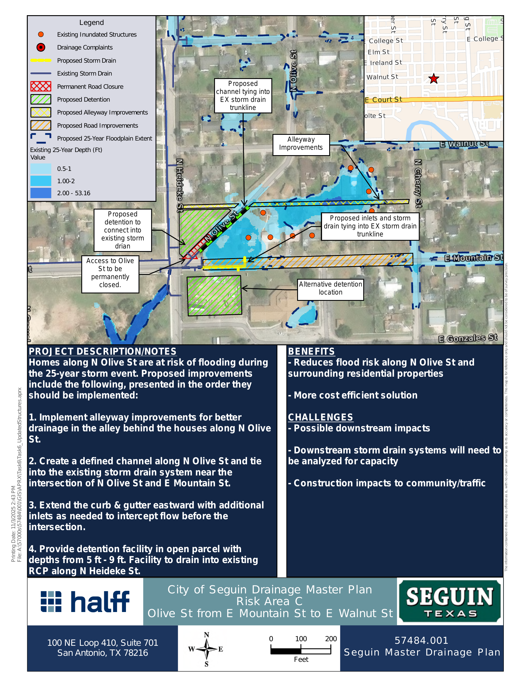
Aerial map of Olive Street near Heideke and Mountain streets showing flood depths, proposed detention areas, alley and road improvements, and a marked permanent road closure.
Proposed drainage concept at Olive, Heideke and Mountain. City of Seguin Drainage Master Plan map for Risk Area C, dated Nov. 3, 2025. It shows the 25-year floodplain, proposed detention, alley improvements, road improvements and the permanent closure of access to Olive Street.Map: Halff / City of Seguin · View the original map (PDF) ↗

The Nov. 17 agenda put the Halff engineering agreement before Seguin City Council for consideration. A proposed resolution would authorize it; the resolution text does not itself establish what council decided. The staff memo identifies Stormwater Utility Fee Bonds as the proposed funding source.

Map

Where and when

The places and times below come from the official pages linked with each one.

What the engineers would design

Seguin's Jan. 20, 2026 Drainage Master Plan identified Risk Area C at Olive, Heideke and Mountain. The staff memo also describes a five-leg intersection there as a crash risk. The proposed concept includes a permanent closure of about 100 feet of Olive northeast of Heideke and Mountain. That closure is part of the proposed design, not a reported change to traffic now.

The Halff agreement describes work along 375 linear feet of N. Olive, 875 feet of E. Mountain between N. Heideke and N. Cherry, and 875 feet of the alley north of Mountain. It covers planning, design, surveying, geotechnical work, bidding and construction-phase services, with an estimated 10-month schedule. Those lengths describe the engineering scope; they do not establish that construction has been funded or begun.

The city's conceptual map proposes alley drainage, a channel connecting toward the existing system near Mountain, inlets, curbs and detention. It also flags downstream capacity and traffic impacts for study. Dated Nov. 3, 2025, the map is a planning reference rather than a final construction plan.

The next record to watch

The council's Nov. 17 minutes or an adopted resolution will establish whether the engineering agreement was authorized. Residents can inspect the proposed terms in the signed Halff agreement while the design question remains open: whether the eventual plan keeps the Olive closure and where it places detention.

The Guadalupe Daily

Guadalupe County, before your second cup.

A clear morning briefing, with direct links to the records and sources behind each story.

By subscribing, you agree to receive The Guadalupe Daily and to our Terms and Privacy Policy. Unsubscribe anytime.